 Mount Ouray to a northbound Continental Divide Trail hiker is the welcoming guardian of the range of giant Sawatch mountains that follows nearly 80 miles of low-lying Cochetopa hills. The inspiring contrast stuck it in my memory, perhaps along with the fact that it marked the vicinity of Monarch Pass, the path to town food after eight long days of trail fare. Today I return with Ann again to reconnect with the CDT here, and possibly to climb Mount Ouray.
We rouse ourselves at 6:30, drive to Marshall Pass, and eat peanut butter, jelly, and banana sandwiches for breakfast. From there we head north a ways on the CDT. I’m surprised at the details I remember – the switchback, the divide crossing, the piped spring, the mine tailings where the road turns to trail. It’s soon time to leave the trail and head up through the trees towards the divide.
Ann is feeling the altitude, making her legs and lungs hurt. She’s daunted to be struggling so soon, but continues anyway, slowly switching back and forth to make the climbing easier. We rest at timber line, then manage another stint up alpine meadow to the divide ridge. Two other hikers pass us here – the only others we see all day.
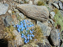
 We stop for frequent rests. Each time we consider turning back, but each time Ann pushes bravely on. Our slow pace is a revelation for me, allowing me to soak up the beauty of each spot with a full breath before moving on. There is time to dwell for a moment on each patch of pink alpine flowers, globe flowers, and forget-me-nots, along with the sparkling rocks and sprawling views. Below a large band of pink quartz we stop for our final rest, and decide to attempt one more push.
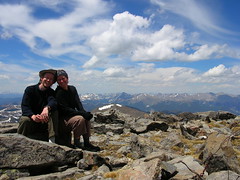
It’s a long one, but we make it. The summit is gorgeous and sunny, with just a gentle breeze blowing. I embrace Ann and welcome her to her first high peak, moved by the effort she put into getting here. It’s unusual for a peak to be so comfortable, and we take advantage of it to hang out and enjoy the views. I see the Continental Divide stretching southwest all the way to San Luis Peak in the La Garitas. Uncompaghre, Capital Peak, Mount of the Holy Cross, and Pikes Peak are all visible. I’m surprised by the lack of snow in the high country – it was a big snow year, but the melt is happening fast. The fact that I made this climb in my Chacos testifies to that.
Eventually we must start down. The descent is long, but we’re buoyed by our success. By the time we reach our base camp, though, we eat a cold dinner and climb into bed without fanfare.
3 responses to “Mount Ouray (13,971′) West Ridge Route”
Pics look great!
Want to tackle Grays/Torreys this Sunday? Mr. Bill and i are busy convincing our significant others that they could at least make it up to grays…
Stunning! Good Job Ann on the peak bagging-WOO HOO! Looks like a very rewarding one at that!
There is a lot of snow this year in the Sierras. Last time I drove by Mt. Whitney-the mountaineers chute was still full of snow. I kinda use that as a barrometer for snow levels up in the mounts.
It should be a good year for climbing-but whitney will have to wait until august this year. A late year for “high sierra” adventures.
Gotta love those Chacos. So, do you have “Z’s” in your feet from the tan lines?
Clare
I wear socks for any serious hikes, but I’ll still probably be sporting Zs by the end of the summer 🙂